
Resource Links | Important Numbers | Terms To Know | Storm News
It’s that time of year again. Florida’s hurricane season lasts from June 1 until November 30. If you’re new to the state or just in need of information on how to keep yourself and your loved ones safe, the WMFE news team has compiled links to some of the most important information you’ll need.
Stay Safe this hurricane season and remember, WMFE is here to keep you up-do-date with life and property saving information.
RESOURCE LINKS
CENTRAL FLORIDA COUNTY EMERGENCY INFORMATION, SHELTERS AND EVACUATION ZONES:
Brevard | Lake | Marion | Orange | Osceola | Polk | Seminole | Sumter | Volusia
STATE/NATIONAL RESOURCES:
NOAA | Fla. Div. Of Emergency Management | FEMA
MORE RESOURCE LINKS:
Disaster Supply Kit Checklist
Flood maps
Know your Zone
Evacuation plan
Shelters
Preparing your homes
Medicine refills
Hurricane safety for people with dementia
Special Needs Registry
Planning for your pet
Horse owner hurricane preparation
What to do if you lose power
Power outage map
Dangers after a hurricane
Cleanup after a hurricane
Food Safety
Generator safety
Where to find gas
Report price gouging
Mosquitoes after a storm
Encountering wildlife after a hurricane
Beekeeper preparedness
IMPORTANT NUMBERS
Emergency help: 911
SAIL Hotline: 1-800-342-3557
FEMA: 1-800-621-FEMA (3362)
Non Emergency Support Services: 211
TERMS TO KNOW
Language surrounding hurricanes and other storms can often be confusing. With that in mind, we’ve also compiled a list of terms and their definitions.
Tropical Cyclone: Low pressure system that forms over warm tropical waters.
Tropical Depression: A tropical cyclone with maximum sustained winds of 38 mph or less.
Tropical Storm: A tropical cyclone with maximum sustained winds of 39 to 73 mph.
Hurricane: A tropical cyclone with maximum sustained winds of 74 mph or higher.
Major hurricane: A tropical cyclone with maximum sustained winds of 111 mph or higher. These are category 3, 4 or 5 hurricanes.
Tropical storm warning: A tropical storm warning is issued when sustained winds of 39 to 73 mph are expected in an area within the next 36 hours.
Tropical storm watch: A tropical storm watch is issued when tropical storm conditions are possible within the next 48 hours.
Hurricane Warning: A hurricane warning is issued when sustained winds of 74 mph or greater are expected in an area within the next 36 hours.
Hurricane Watch: A hurricane watch is issued when hurricane force winds are possible in an area within the next 48 hours.
Eye: The center of the hurricane.
Eyewall: The band or ring of clouds that surrounds the eye of a hurricane.
Landfall: The moment the center of the hurricane reaches the coastline.
Outer bands: An outer ring of rainfall and thunderstorms that surrounds a hurricane. Usually this is the first part of the storm to make landfall.
Storm surge: A rise in sea level corresponding with a hurricane or other intense storm at sea.
Cone of uncertainty: A diagram showing the projected path of a tropical storm or hurricane over the next five days.
Spaghetti plot: A diagram showing multiple paths a tropical storm or hurricane could take based on different prediction models.
Hurricane names: Any tropical cyclone that becomes a tropical storm or hurricane gets a name. Here’s the list of this year’s names.
National Hurricane Center: The National Hurricane Center or NHC issues watches, warnings and advisories for tropical weather.
Hurricane season: The Atlantic hurricane season runs from June 1 through November 30. This is when tropical cyclones are most likely to form in the Atlantic.
The peak of hurricane season: September 10 is the peak of hurricane season. Most hurricanes form between mid-August and mid-October.
Saffir Simpson Hurricane Wind Scale (ranking): The scale ranks a hurricane’s potential to do property damage based on its maximum sustained wind speeds. Hurricanes can be category 1, 2, 3, 4, or 5 storms.
Latest Storm News
-
 Above normal rainfall this winter could lead to a less active wildfire season across parts of Florida
 -
 Rounds of thunderstorms could lead to localized flooding over Florida's Panhandle. Meanwhile, over the peninsula, the warm trend will continue until the end of the weekend.
 -
 Freeze alerts are already in effect for the Panhandle and North Florida as temperatures are expected to drop to the lowest they've been in over a year.
 -
 Residents of the Panhandle woke up to an uncommon sight on Tuesday morning: Snow flurries and freezing rain. The conditions were brought on by the passage of a strong cold front through the Mississippi Valley and the Southeast.
 -
 Sub freezing lows are forecasted for the Panhandle and North Florida on Wednesday morning. Wind chills in the 30s are expected as far south as Tampa and Orlando.
 -
 Just days after strong storms and numerous tornadoes across the Panhandle, the risk for severe thunderstorms returns
 -
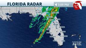 A severe weather system tracked across the Southeast this morning, and it spawned reports of tornadoes and damaging wind gusts across Florida’s Panhandle.
 -
 In effect until Tuesday at 9 p.m. as a powerful line of storms moves across the state.
 -
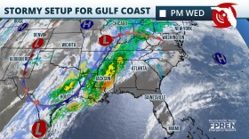
 Multiple rounds of dangerous thunderstorms are expected as another strong winter storm barrels across the country. Damaging winds and a few tornadoes (potentially strong) are possible, especially over the Panhandle and North Florida.
 -
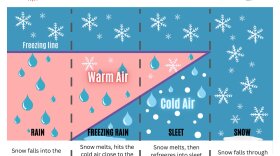
 While Florida is known for its generally mild winters compared to many other parts of the country, winter weather, including sub-freezing temperatures, freezing rain, and even snow, are possible over parts of the state.
 -
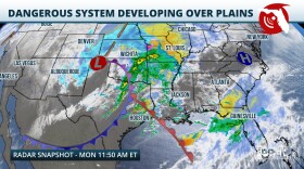
 Floridians may not be wearing mittens and scarfs this Christmas. A frontal system moving through will increase chances for showers and thunderstorms on Sunday and Monday for much of the state.
 -
 DeSantis directed State Guard Director Mark Thieme to “mobilize whatever number of Florida State Guard members you deem necessary.”


